GOES-15
 NOAA’s GOES-15 Geostationary Operational Environmental Satellite is launched from Cape Canaveral into geosynchronous orbit to monitor weather patterns over the United States. In accordance with NOAA’s policy of having standby weather satellites already in orbit before their predecessors are decommissioned, GOES-15 is held in reserve until late 2011, when it will become the primary GOES-WEST satellite. It remains in orbit on active weather-watching duty.
GOES-14
 NOAA’s GOES-14 Geostationary Operational Environmental Satellite is launched from Cape Canaveral into geosynchronous orbit to monitor weather patterns over the United States. It will be held in reserve until August 2012, when it will be activated to begin monitoring Tropical Storm Isaac as it closes in on the Gulf Coast, and it will redirected to monitor Hurricane Sandy’s approach and landfall on the east coast of the United States. In 2013 it will be moved to a position near the GOES-EAST geostationary position to cover the Atlantic Ocean and the east coast during one of GOES-13’s many technical outages. It remains in orbit on standby.
GOES-13 goes up
 NOAA’s GOES-13 Geostationary Operational Environmental Satellite is launched from Cape Canaveral into geosynchronous orbit to monitor weather patterns over the United States. It will be held in reserve until 2010, when it will be moved to the GOES-EAST position to replace GOES-12, which is suffering chronic attitude control thruster glitches. GOES-13 is yet another evolutionary step up in the GOES satellite hardware, but it will suffer its own share of hardware issues, including a series of inexplicable faults which will cause brief losses of weather coverage, and a later fault which disables infrared imaging capability. Some of these hardware failures will be attributed to micrometeoroid collisions.
GOES-12 goes a little haywire
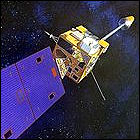 NOAA’s GOES-12 Geostationary Operational Environmental Satellite is launched from Cape Canaveral into geosynchronous orbit to monitor weather patterns over the United States. It will be held in reserve until 2003, when it will be moved to the GOES-EAST position to replace GOES-8, which is nearly out of fuel. Though GOES-11 has been in orbit longer than GOES-12, this satellite is activated first to use a solar imaging instrument (which will fail in 2006). Once in its active position, GOES-12 suffers from chronic thruster problems due to errors made during wiring of its primary and backup maneuvering thrusters; one outage will prove to be severe enough that the still-active GOES-10 must cover GOES-EAST coverage. In 2008, another thruster glitch will cause GOES-12 to temporarily lose all attitude control. In 2010, GOES-13 will replace GOES-12 in the GOES-EAST orbit thanks to the continued attitude control issues; GOES-12 remains in orbit as a backup.
GOES-11 goes weather watching…after a while
 After over a year of launch delays, NOAA’s GOES-11 Geostationary Operational Environmental Satellite is launched from Cape Canaveral into geosynchronous orbit to monitor weather patterns over the United States. It will be held in reserve until 2006, when it will be moved to the GOES-WEST position to replace GOES-10, which is nearly out of fuel. The longevity of its predecessor means that GOES-11 doesn’t begin its active daily weather-watching until a year after the end of its projected five-year design lifespan, and GOES-12 will actually go active before GOES-11. GOES-11 will remain in service through the end of 2011, when it will boost itself into a higher-than-geostationary “graveyard” orbit and shut down.
GOES-10 lifts off
 NOAA’s GOES-10 Geostationary Operational Environmental Satellite is launched from Cape Canaveral into a geosynchronous orbit to monitor weather patterns over the United States. GOES-10 suffers significant hardware issues upon reaching orbit, including the failure of sun-tracking sensors to orient its solar panels, and it will be over a year before it is pressed into operational service in the GOES-WEST orbit by the failure of GOES-9’s attitude control system. GOES-10 will operate there until 2006, when, upon the launch of GOES-11, it takes up a new position, GOES-SOUTH, monitoring South America and watching for Atlantic Ocean hurricane and tropical storm formation. It will be briefly moved back into the GOES-EAST orbit in late 2007, and with just enough maneuvering fuel left to boost it, it will finally be retired to the above-geostationary “graveyard” orbit in 2009.
Fort Smith, Arkansas Tornado
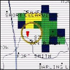 A small but powerful tornado touches down near theLogBook.com’s home office in downtown Fort Smith, Arkansas shortly after 11pm. It traverses two more counties, and kills three people, before dissipating. This is part of a larger tornado outbreak that has plagued much of Oklahoma earlier in the day. The storm is later judged to be an F3 tornado.
GOES-9 goes up
 NOAA’s GOES-9 Geostationary Operational Environmental Satellite is launched from Cape Canaveral into a geosynchronous orbit now designated GOES-EAST to monitor weather patterns over the United States; its predecessor, GOES-8, remains in orbit in the GOES-WEST position. GOES-9’s hardware configuration is identical to that of GOES-8, and both suffer minor glitches which will be corrected prior to launch in the GOES-10 satellite. GOES-9 will remain in the GOES-EAST orbit until it is retired from active weather-watching duty in 1998 due to those hardware problems, though it will be pressed back into served and leased to Japan to replace one of that country’s weather satellites between 2003 and 2005. GOES-9 will finally be retired in 2007.
GOES-8 goes up
 NOAA’s GOES-8 Geostationary Operational Environmental Satellite is launched from Cape Canaveral into a geosynchronous orbit now designated GOES-EAST to monitor weather patterns over the United States; its predecessor, GOES-7, takes up the GOES-WEST position. GOES-8 is a major design evolution in the GOES weather satellite series, incorporating new hardware, some of which proves to be less sturdy than is required for an extensive orbital tour of duty. GOES-8 will remain in the GOES-EAST orbit until it is retired from active weather-watching duty in 2003 and shut down in 2004.
The changing climate
 A leading NASA climate scientist, Dr. James E. Hansen, addresses the United States Congress with a warning: the past five months of 1988, the hottest months in the history of weather records, are the beginning of a dangerous trend in Earth’s climate history, and studies conducted by experts show that the cause is increasing man-made pollution. Though Hansen’s claims will continue to be debated for decades (while only slow progress is made in the transition from fossil fuels to renewable energy in that same time), the five-month period in question will not be the last consecutive stretch of rising worldwide temperatures.
GOES-7 goes up
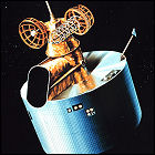 NOAA’s GOES-7 Geostationary Operational Environmental Satellite is launched from Cape Canaveral into a geosynchronous orbit now designated GOES-EAST to monitor weather patterns over the United States. Originally intended for a 1986 launch, GOES-7 has been kept on the ground by the investigation into the destruction just after launch of its predecessor, GOES-G. GOES-7 will become the first of the GOES satellites to operate in both the GOES-EAST and GOES-WEST orbits, and will be retired from active weather-watching duty in 1999, becoming a communications relay satellite until it is decommissioned in 2012.
GOES-G goes nowhere fast
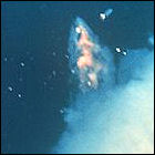 NOAA’s GOES-G Geostationary Operational Environmental Satellite is launched from Cape Canaveral, intended to replace the failed GOES-5 satellite in a geosynchronous orbit over Earth’s western hemisphere. But an electrical fault destroys GOES-G’s Delta booster in flight, and the rocket explodes 71 seconds into its flight. This is NASA’s first attempt to launch a rocket since the Space Shuttle Challenger disaster earlier in 1986, raising new questions about the space agency’s reliability and safety record.
Landsat 5
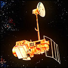 NASA launches Earth resource observation satellite Landsat 5, virtually identical to the Landsat 4 satellite launched in 1982. Like Landsat 4, Landsat 5 is capable of sending real-time data to Earth through the Tracking & Data Relay Satellite (TDRS) system. Landsat 5 becomes the longest-operating Earth observation satellite, outliving its anticipated three-year design life by a factor of ten and not becoming inoperable until 2013; by the time it was shut down, Landsats 7 and 8 had been launched. Among the events Landsat 5 witnessed from orbit were a tsunami that killed nearly a quarter million people along Indonesia’s coastlines in 2004, and the 1986 meltdown of the Chernobyl nuclear reactor in the Soviet Union.
GOES-6 goes up
 NOAA’s GOES-6 Geostationary Operational Environmental Satellite is launched from Cape Canaveral into a geosynchronous orbit over 135 degrees west longitude on Earth, a position which will change several times over GOES-5’s career until 1988, allowing it to monitor weather over the continental United States and Europe. GOES-5’s primary set of “eyes” will fail in 1989, leaving GOES-7 as the sole working GOES weather satellite until the mid-1990s. Even while “blind”, GOES-5 will serve as a communications relay satellite until its boost to “graveyard” orbit and shutdown in 1992.
Landsat 4
 NASA launches Landsat 4, the fourth Landsat Earth resource observation satellite and the first to be redesigned from the ground up (previous Landsats had been based on NASA’s Nimbus satellites from the 1960s and ’70s). For the first time, Landsat data processing and distribution is handled by another government agency, the U.S. Geological Survey, which partners with NASA on all future Landsat satellites. Landsat 4 is the first Landsat to link up to NASA’s TDRS (Tracking & Data Relay Satellite) system, thus enabling real-time data transmission to Earth even when Landsat 4 isn’t passing over a ground station. Landsat 4 remains operational through the end of 1993.
GOES-5 goes up
 NOAA’s GOES-5 Geostationary Operational Environmental Satellite is launched from Cape Canaveral into a geosynchronous orbit over 85 degrees west longitude on Earth, a position which will change several times over GOES-5’s career until 1988, allowing it to monitor weather over the continental United States and Europe. GOES-5’s primary set of “eyes” will fail in 1984, forcing NOAA to return GOES-1 and GOES-4 to service until a replacement can be launched in 1987. Its usefulness as a weather satellite at an end, GOES-5 will be boosted into a graveyard orbit in 1990.
Totable Tornado Observatory
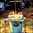 Researchers and storm chasers from the National Weather Service’s Severe Storms Laboratory in Norman, Oklahoma make the first field deployment of the 300-pound TOtable Tornado Observatory (TOTO) instrument package, a modified oil drum filled with meteorological instrumentation which is intended to be placed directly into the path of an oncoming tornado. The first deployment, in north Texas, yields no data – no tornado forms for TOTO to study. Over the next five years, despite several “close calls”, TOTO is never successfully placed in the direct path of a tornado. The TOTO program is discontinued in 1987.
GOES-4 goes up
 NOAA’s GOES-4 Geostationary Operational Environmental Satellite is launched from Cape Canaveral into a geosynchronous orbit over 98 degrees west longitude on Earth, a position which will change several times over GOES-4’s career until 1988, allowing it to monitor weather over the continental United States and Europe. In 1988, GOES-4 will become the first satellite to be boosted into a “graveyard” parking orbit using its remaining propellant, leaving it intact in a higher-than-geostationary orbit to avoid collisions with operational satellites.
Nimbus 7
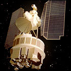 NASA launches the Nimbus 7 satellite, the last of a series of experimental satellites designed to test new weather and climate detection technologies. This satellite tests more precise attitude control systems and instruments designed to monitor the layer of ozone within Earth’s atmosphere. Many of the technologies developed in the Nimbus series are transferred not to future weather satellites, but to future Landsat Earth observation satellites.
GOES-3 goes up
 NOAA’s GOES-3 Geostationary Operational Environmental Satellite is launched from Cape Canaveral into a geosynchronous orbit over the Indian Ocean, replacing the first operational GOES satellite, GOES-1. GOES-3 will serve as a working weather satellite for over a decade, ultimately decommissioned from that role in 1989 and then serving as a communications satellite for the Pacific Ocean region and Antarctica, a role it continues to fill over 35 years later.
Landsat 3
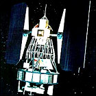 NASA launches Landsat 3, the latest in a constellation of satellites derived from the design of the experimental Nimbus weather satellites. This is the last Landsat to use the Nimbus framework, and the last to be managed exclusively by NASA; Landsat 3 remains in service through 1983.
“A threat of disaster” in Antarctica
 British glaciologist John H. Mercer publishes a report in Nature postulating that continued growth of fossil fuel use could lead to a runaway carbon dioxide greenhouse effect in Earth’s atmosphere, with the glaciers of western Antarctica particularly vulnerable to rising temperatures of both air and water. The glacial melting, Mercer says, could be rapid and catastrophic, leading to as much as a five-meter rise of global sea levels by 2028, putting “low-lying areas such as much of Florida and the Netherlands” underwater. Though initially treated as a “worst case scenario”, Mercer’s theory will gain traction as global ocean temperatures rise (and as glacial melting picks up speed in Antarctica) in the early 21st century, ultimately becoming the predominant theoretical timeline for sea level rise and gaining an informal name: the “John Mercer effect”.
GOES-2 goes up
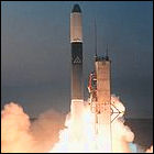 The second in a new generation of geosynchronous weather satellites is launched for the National Oceanic & Atmospheric Administration, GOES-2. An acronym for Geostationary Operational Environmental Satellite, GOES-2 is initially positioned at a point over 60 degrees west longitude on Earth, though it will be repositioned several times in its career as a weather satellite. In 1993, it will cease weather monitoring operations and will act chiefly as a communications satellite serving islands in the Pacific Ocean, as well as manned research facilities in Antarctica. GOES-2 will serve that function through 2001.
NOAA-5
 NASA and the National Oceanic & Atmospheric Administration launch NOAA-5, a weather satellite intended to operate in a near-polar low Earth orbit. Within two weeks of its launch, NOAA-5 proves instrumental in tracking Hurricane Belle, a category 1 hurricane, as it approaches and makes landfall in the northeastern United States. NOAA-5 will operate without any major malfunctions through July 1979.
GOES-1 goes up
 The first in a new generation of weather satellites operating in geosynchronous orbit for the National Oceanic & Atmospheric Administration, GOES-1, is launched from Cape Canaveral. An acronym for Geostationary Operational Environmental Satellite, GOES-1 is positioned over the Indian Ocean, where it is expected to become but the first in a constellation of weather satellites monitoring Earth’s atmosphere in both visible and infrared light. In 1978, GOES-1 will be repositioned over the Pacific Ocean, which it will monitor until it is decommissioned in 1985, after almost ten full years of operation.
Nimbus 6
 NASA launches the Nimbus 6 satellite, designed to observe weather patterns from orbit and test new weather and climate detection technologies. In addition to continuing the microwave and infrared observations carried out by Nimbus 5, Nimbus 6 studies the amount of solar radiation reaching or reflected by Earth, and sends real-time observations to the experimental ATS-6 satellite, allowing NASA to test techniques and technologies that will be used in the shuttle-era TDRS (Tracking & Data Relay Satellite) system.
Landsat 2
 NASA launches its second Landsat satellite, originally named ERTS-2 (Earth Resource Technology Satellite) and still based on the Nimbus experimental weather and Earth-observation satellites. Originally intended to be online for a year, Landsat 2 functions through 1982, carrying a suite of instruments and sensors nearly identical to that of Landsat 1.
From Weather Radio to Disaster Radio
 After years of studies into the feasibility of constructing a nationwide disaster alert system, NOAA Weather Radio is officially designated the “sole government operated radio system” for both weather-related disasters and other major emergency announcements (nuclear attacks are specifically mentioned in the declaration from President Ford). This shift in policy toward using the National Weather Service’s radio infrastructure for all potential disaster situations is at least partially inspired by the April 1974 tornado “Super Outbreak” in the midwest. For the first time, Congress approves a budget earmarked specifically for weather radio, topping $3,000,000 for expansion in 1976.
NOAA-4
 NASA and the National Oceanic & Atmospheric Administration launch NOAA-4, a weather satellite intended to operate in a near-polar low Earth orbit. NOAA-4 is based on the already-flown ITOS satellite design, and will operate without any major malfunctions through November 1978.
NOAA-3
 NASA and the National Oceanic & Atmospheric Administration launch NOAA-3, a weather satellite intended to operate in a near-polar low Earth orbit. NOAA-3 is based on the already-flown ITOS satellite design, and will wait in orbit until March 1974, when the failure of an instrument aboard its predecessor, NOAA-2, requires putting NOAA-3 on full weather-watching duty, where it will remain without any major malfunctions through August 1976.